

Preview
Creation Date
1798
Description
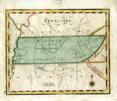
Scale: 1 inch = circa 66 miles. Hand-colored map from J.T. Scott's New and Universal Gazetteer, 1798-1800. Notations include early settlements, military reservations, and the location of Native American villages. Map indicates terrain in some areas (e.g. "high broken ground" and "way nearly level"). The Mero district is shown divided into Sumner, Davidson, and Tennassee with "Naskville" also noted. Fort Massac is noted on the Ohio River. Includes portions of Kentucky, Georgia, North Carolina, South Carolina, and Louisiana.
Dimensions
18 x 21 cm
Rights
The Archives of Appalachia at East Tennessee State University provides access to these materials for the purposes of research and education and is not aware of any U.S. copyright protection or any other restrictions for this item. Any commercial uses of the materials or any uses that exceed the limits of fair use and other relevant statutory exceptions may require the permission of any copyright holder(s). It is the user's obligation to determine and satisfy copyright or other use restrictions when publishing or otherwise distributing materials. Preferred citation: [identification of item], Archives of Appalachia, East Tennessee State University.
Keywords
Archives of Appalachia, rare map, Tennessee
